
Wormleighton Deserted Medieval Village
What is it?
Earthworks of a deserted medieval village north of Banbury
Maps
Ordnance Survey
- Landranger Map - 151
- Explorer Map – 206
Grid reference - SP 44419 54169
Parking - Parking with care on roadside near St Peter’s Church.
Public transport – Limited bus service (5 per day) between Leamington Spa and Banbury stops at Fenny Compton Wharf from where the site is a 2km walk along the road or canal towpath. Not Sundays www.stagecoachbus.com
Access - The site is in farmland in a field crossed by a public footpath. There is also a footpath along the canal towpath. There may be livestock in the field. Nearest facilities are available at The Wharf, Fenny Compton.

What you can see
Before setting off - the following article by Harry Thorpe will help you to orientate yourself on site – there is an aerial photograph and a plan which you will find helpful.
http://archaeologydataservice.ac.uk/archiveDS/archiveDownload?t=arch-281- 1/dissemination/pdf/cba_rr_012.pdf (click ‘accept’ and go to page 141)
Wormleighton is first recorded in an Anglo-Saxon document of AD 956 and in the Domesday Book when it had a population between 200 and 250 people. The village continued to grow in the 12th and 13th centuries, but declined in the later 14th and 15th centuries. In the 1490s the site was turned over to sheep pasture making around 60 people homeless.
The estate was bought in 1506 by John Spencer, who in 1519 abandoned the original manor house, and built a new stone manor house on the hill top, adjacent to the church, parts of which can still be seen today. Spencer also laid out fishponds over part of the site of the village.

Take the footpath leading downhill along a trackway below the church going away from the modern village.

Before going far you will see a metal farm gate on your left beyond which you see the first and earliest of the earthworks associated with the village comprising six small house platforms terraced into the hillside and defined by small banks up to 1m high.

There is a second gate further down from which you can get another view looking back up-hill towards the house platforms and downhill towards the earthworks of a large rectangular fish pond (sometimes water filled) constructed on the site after the people were moved off the village site.
Continue down-hill past the gates to the sewage works and cross a stile into the field beyond.
Climb to your right to the highest level from where you have a wide view over the main earthworks of the medieval village. You may be able to make out the route of the main street running from the corner of the field in which the large rectangular pond is located down towards the line of the canal bounded by a hedge in the distance The upper part of this street was converted into stew ponds in the 16th century and you can make out the lumps and bumps associated with these going down as far as a telegraph pole in the middle of the field.
The main village street originally led from the church down to a ford crossing a stream which ran along part of the route now occupied by the canal. The settlement included an area of house enclosures (tofts), allotments and gardens (crofts), laid out on either side of this main street. They are best preserved in the area furthest away and close to the canal and can be seen from the towpath.
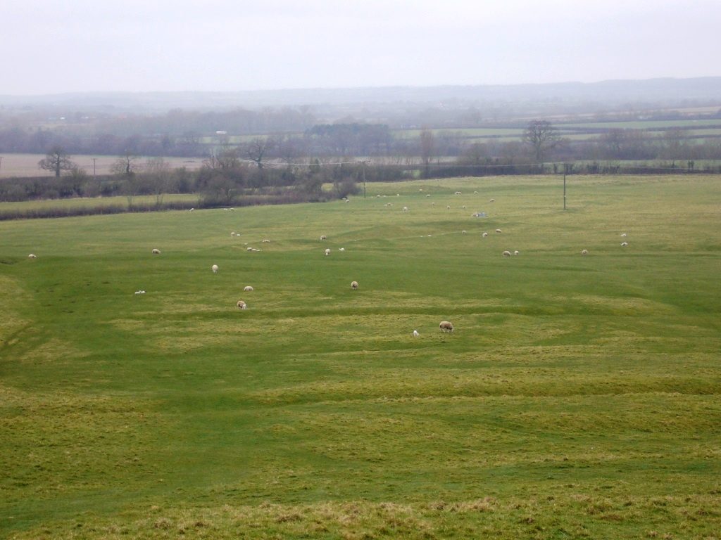
The area of earthworks, a series of regular ditches, closest to you (in the photo above) are part of an irrigation system for water meadows that were created on the site after the people of the village were moved out.

Cross the field along the footpath heading down hill towards the hedge on the other side of the field. The footpath runs along a slight holloway which was the old road to Southam.
If you have difficulty finding this just make your way to the hedge and locate the stile leading to the canal and when you look back up the hill the Holloway will be easier to see – as in the photo.

As you go downhill towards the canal, (head for the brick canal bridge when you can see it above the hedge) on your right you will be able to see the remains of ridge and furrow forming part of the open field system associated with the settlement.

Eventually you will see a stile which passes through an old hedge boundary and leads to bridge 133 of the Oxford Canal. Cross the bridge and turn immediately left down onto the towpath over another stile.

This part of the canal was constructed between 1774 and 1778 and if you look closely at the brickwork on the bridge abutments you can see where it has been scored and marked with rope marks caused by generations of people using horses to tow their boats along the canal.

Turn right and carry on along the canal until you reach a white marker with numbers (the OS grid reference) stencilled on it.
Looking into the field opposite you are looking back up the old main street of the village and here you should be able to make out the earthworks associated with the crofts and tofts which were defined by boundary ditches, measuring up to 1m deep and 1m to 2m wide having a flat area or platform on which the house was built.

Continue until you reach 3 marker posts warning people fishing of overhead cables! At this point, in the field opposite you can see the earthworks of the double moat that surrounded the old manor house. The moat is up to 4m deep in places.
The Oxford canal actually cuts through the eastern island of the moat. The manor house on this site was replaced in the 16th century by a new one near to the church.
From here you can continue your walk along the canal to The Wharf canalside public house or return back across the field containing the earthworks and explore St Peter’s Church and gatehouse.
The site is a scheduled monument which means it is protected by law.
This means metal detecting and unauthorised digging at the site is not allowed.

If approaching on public transport from The Wharf Inn take the road to Wormleighton (approximately 1.7km walk) taking care of traffic until you arrive at a junction with a triangular village green and old bus shelter, turn left. You will soon see the early 17th century stone gatehouse to the manor house and St Peter’s Church beyond.
Having explored these follow the route outlined above and return to The Wharf along the canal.
Find out more:
- Page, W, The Victoria History of the County of Warwickshire, (1908), 235
- Thorpe, H , The Lord and the Landscape, Transactions of Birmingham and Warwickshire Arch Soc Vol 80 (1965)
- Bond, C, J, Transactions of Birmingham and Warwickshire Arch Soc Vol 86 (1974)
- Beresford, W, M, Transactions of Birmingham and Warwickshire Arch Soc Vol 66 (1945)
Links:
https://historicengland.org.uk/listing/the-list/list-entry/1016438
DMV: http://timetrail.warwickshire.gov.uk/detail.aspx?monuid=WA1308
Fishponds: http://timetrail.warwickshire.gov.uk/detail.aspx?monuid=WA1309