Excavations adjacent to The Lunt Roman Fort, Baginton
Recent Work by Archaeology Warwickshire by Bryn Gethin
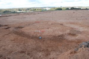
A very large area was excavated to the east of the Lunt Roman fort in advance of the construction of a new Jaguar Land Rover facility. The site had previously been evaluated by Oxford Archaeology in 2012. This had identified a few features and, perhaps most importantly, a cremation cemetery. It was thought likely that this was associated directly with the Roman fort and was therefore likely to be relatively early in date and to possibly have been mainly for Roman soldiers, although The Lunt is known to have had an adjacent vicus. The site was very large and the underlying geology consisted mostly of sand. This proved to have caused some unusual conditions for preservation.
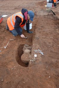
Above : Archaeologist Rob Jones excavates the first part of a rather good pit.
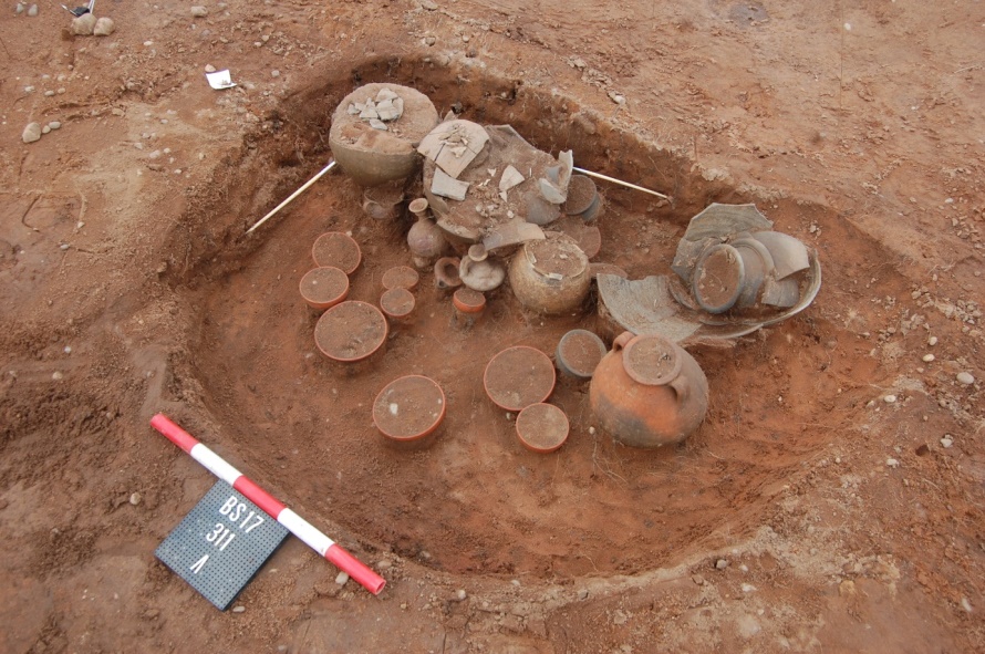
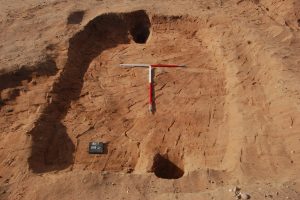
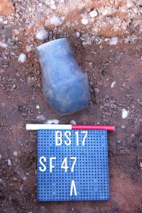
The cremation cemetery proved to contain over sixty burials, many in pots. The area had been ploughed throughout the medieval period and so some of the burials had been partially truncated. However, sand is easy to dig, even without modern tools, and other burials had been buried at a greater depth. Items within burials included numerous complete pots, two mirrors, two glass bottles, brooches, the odd coin (one definitely of Vespasian), pins, a ring with an intaglio and the remains of at least two copper bound boxes. The star feature consisted of a large pit with 23 near complete pots and an oil lamp. Human bone survived within the cremations as the chemical changes caused by burning make it almost impervious to the very acidic sandy geology.
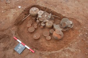
Above: The final view, 23 pots and an oil lamp later
Some finds from the site
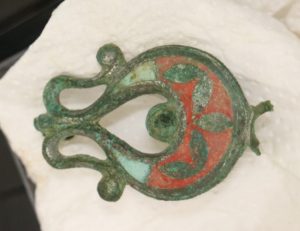
One of the brooches from the above pit, after conservation.
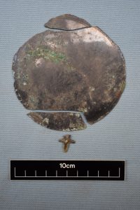
Bronze mirror. If you have ever wondered how they would work (after all just how reflective is polished bronze?) then this shows that they were silvered.
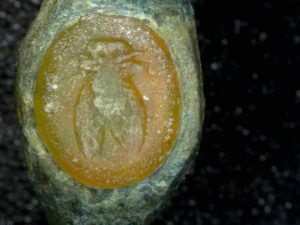
Intaglio ring after conservation, the design can now be seen to be a wonderful bee.
Prehistoric and Anglo-Saxon remains
But……the site was not content with only a Roman cremation cemetery. A small ring ditch was probably the remains of a prehistoric barrow and several other prehistoric pits were uncovered.
Below
Also numerous Anglo-Saxon features were exposed, including several sunken featured buildings, more commonly known to diggers as grub huts. A small inhumation cemetery was also excavated although no traces of bone were noted, showing just how acidic the geology was. Finds included two complete Saxon pots, a complete shield boss and a rather crushed copper alloy hanging bowl. The unusual nature of the geology meant that some preserved wood still overlay this bowl and a cord around its inner lip, presumably used to hang the bowl, was so well preserved that it looked like you could tie your shoes with it. This site was also run by Nigel Page.
Above: A classic example of an Anglo-Saxon ‘grub hut’
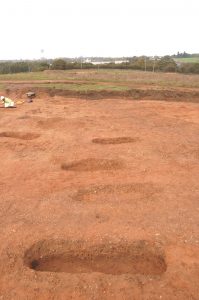
Above: Saxon inhumation cemetery, with no bone surviving at all! Coventry Cathedral is visible on the horizon at centre left. The strip of sand in the far distance, on the end of a small ridge, was covered in prehistoric pits and Saxon grub-huts.
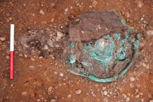
Above: The remains of a copper alloy hanging bowl, beneath a piece of preserved wood. The hanging cord can be seen protruding from the bottom left of the rim.
Above: A complete decorated Saxon pot from another grave
Mansell Farm, Newbold-on-Stour
Recent Work by Archaeology Warwickshire by Bryn Gethin
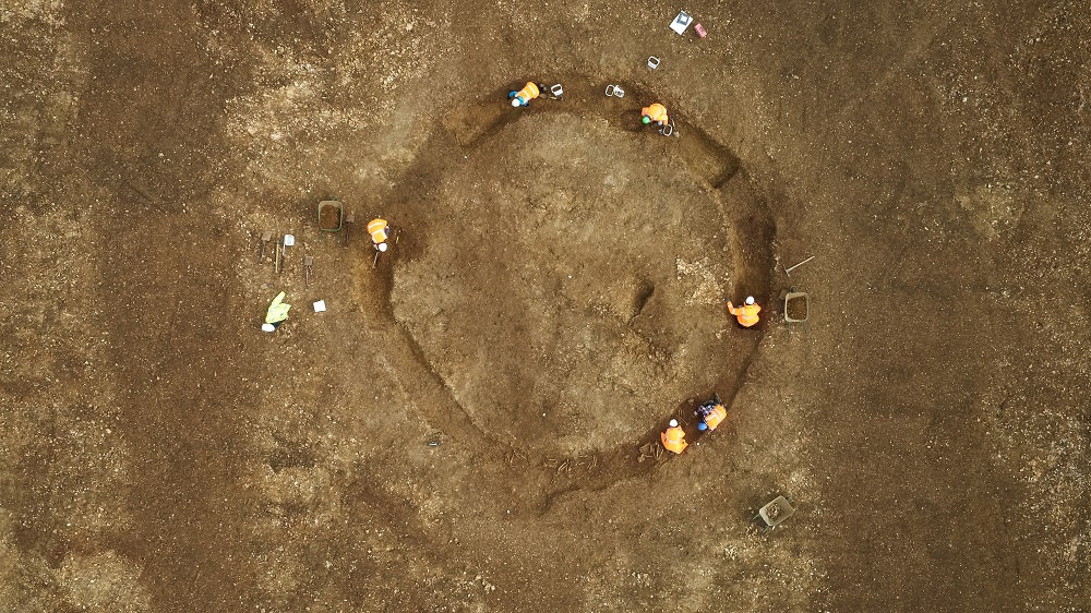
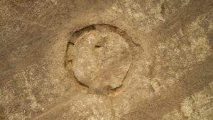
Soil stripping on this site, in advance of new house building and following on from an Archaeological evaluation in 2015, exposed a ring ditch. This had previously been noted on a geophysical survey carried out for the project and had been confirmed during the evaluation stage. It was generally assumed to be the remains of a barrow, and was expected to date from the Bronze Age. However, the archaeologists were in for a surprise when one arc of the ditch, encompassing just under a quarter of its total area, turned out to contain five crouched burials. These have been dated to the Early - Middle Bronze Age and the ring ditch turned out to have two small ‘causeways’ across it, consisting of unexcavated soil. Therefore it is now considered to be a small henge, or to use the more technical archaeological term, a hengiform monument. The geology of the site was relatively unusual for Warwickshire and consisted of Lias limestone. This was fortunate as it is not very acidic and had not dissolved the skeletons too badly. Current analysis of the bones suggests that the burials were five adults, including one younger and one older individual. Two of these were certainly male and it is thought possible that they consist of a family group. Such sites have been rare finds in Warwickshire although a group of 4 was excavated at Bidford-on-Avon by Archaeology Warwickshire in 2015. The site was run by Nigel Page.
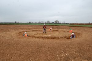
Above: The site being excavated, giving a good indication of its modest size.
Above: Mansell Farm, the hengiform monument. Note the clear furrows and how they do not deviate over the top of the feature, suggesting there was never much of an earthwork (such as a barrow mound). Other linear features are backfilled evaluation trenches.
Above: The mostly excavated ditch with the five burials visible in the top right arc
Sandwell Valley, West Bromwich
A free heritage trail leaflet is now available from Sandwell Park Farm. The trail includes Sandwell Priory and several other sites around it. New on-site interpretation panels explain the eighteenth-century Sandwell Hall and its surrounding park. Objects found in excavations are displayed in a museum at Sandwell Park Farm.
www.sandwell.gov.uk/sandwellvalleyw.sandwell
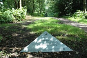
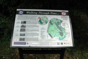
Walking through time, Sutton Park
The Friends of Sutton Park Association and the Sutton Coldfield Civic Society have created six self-guided walking trails to explain some of the many well-preserved archaeological remains. Each trail starts at a gate or car park with an explanatory panel, and markers indicate individual sites along the route. The trails include prehistoric burnt mounds, a Roman road, the boundary and subdivisions of the medieval deer park, fishponds, wood boundaries, sawpits, millpools, a former racecourse and golf course, military practice trenches and targets, and a nineteenth-century estate, a railway and buildings. A map of the trails is obtainable at Sutton Park Visitor Centre, near Town Gate.
Sutton Park is open every day, admission free, car parking charge on summer Sundays and Bank Holidays.
The Friends of Sutton Park Association arrange two guided walks each year based on the trails. The next one is on Saturday 30 September starting at 10am at the Town Gate, off Park Road. Free, no need to book.