
Brinklow Castle
What is it?
Impressive earthworks of a motte and bailey castle dating back to the Norman period located between Rugby and Coventry
Maps
Ordnance Survey
Landranger Map – 140
Explorer Map - 222
Grid reference SP 43820 79566
Nearby postcode – CV23 0LQ
Parking - There is a small parking area in Ell Lane where there is an interpretation panel and a gate which takes you directly to the motte. There is also on street parking on the B4455 (Broad Street) near to the church and a signed village car park.
Public transport - Buses between Rugby and Coventry stop in Broad Street from where it is possible to access the site along footpaths at various locations.
For bus times and numbers see http://www.networkwestmidlands.com
Access - The site is in public open space. The Coventry Way footpath passes through the site. From Broad Street there is a public footpath along Butchers Close (opposite the Pumpkin Deli) another beside The Raven public house (see OS map). There is a permissive route across the field next to the church where you will also find an interpretation panel.
There is also a public footpath at the Ell Lane car park. There are no formal paths on site and access is over rough grassland which can be muddy at times. Benches and picnic tables are provided on site. There are public houses, a café and local shops in the village.


What you can see
The site can be approached along several footpaths from different directions. The car park in Ell Lane is closest to the motte but if you are arriving by bus you can access the site from footpaths off Broad Street.

Brinklow was a timber castle built as part of William the Conqueror's northern campaigns in 1069 but it was needed as a defensive site for a relatively short period and hence was never reconstructed in stone as happened at nearby Warwick castle.
It is thought that when the Normans arrived they found an existing structure here, probably a large prehistoric burial mound or even a Roman signal station, and enlarged it to create the motte we see today. Locally it is known as The Tump.
This is one of the best examples of this type of site in the country.
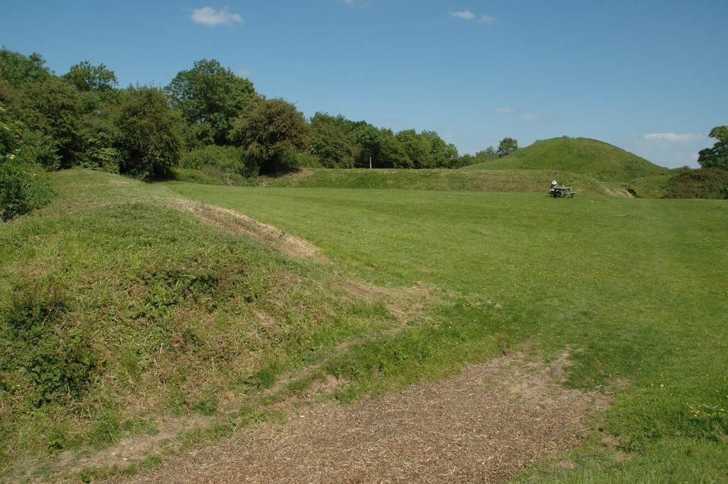
The substantial motte and bailey earthworks are situated on high ground overlooking the route of the Fosse Way Roman road which continued to be a strategically important route well into the medieval period.
The site consists of a flat topped motte some 15m high surrounded by a ditch located at the east end of a double bailey enclosure some 0.8h in extent.

From the top of the motte (take care climbing the motte especially when the weather has been wet) you can appreciate the site and its setting. Looking towards the tower of the church you can look down directly onto the bailey which is divided into inner and outer enclosures both surrounded by a bank and ditch up to 4m deep in places and divided in two by another ditch. Causeways, gaps in the defences, between the two enclosures and in the outer defences to the west probably mark the original entrances to the castle site.
The church that can be seen today, which stands just outside the castle entrance, dates mainly from the 15th century but it is likely there was a church here in the Norman period but it would have been much smaller and constructed of timber like the castle.

Looking to the south, south east and east of the castle the remains of medieval ridge and furrow cultivation can be seen in the fields beyond. Also looking in this direction you can see the Fosse Way, the modern B4455, which once continued straight on past the site of the castle. The straight alignment of the Fosse can be seen carrying on towards the castle in the form of a hedge- line. From the motte you can see that the castle was built on top of the Fosse Way. This was a not uncommon Norman practice and presumably aided their control of well-used route ways.
A similar thing can be seen at Oversley Castle near Alcester, which sits astride Ryknild Street. At some point in time the route was diverted and the modern road, now Broad Street, runs through the centre of the village.

It is possible to walk through the fields containing the ridge and furrow by following the Coventry Way footpath (green markers). When you leave the motte follow the footpath through a gap in the south west corner (to the left as you look down from the motte) of the outer bailey and go down a steep flight of steps then follow the path round to the left going through a kissing gate into the field with the ridge and furrow.

If approaching from Broad Street take the footpath along Butchers Close and follow the footpath signs turning left into the ridge and furrow field and walk towards the castle through the gate in the far corner of the field.
The site is a scheduled monument which means it is protected by law.
This means metal detecting and unauthorised digging at the site is not allowed.

The late medieval church of St John the Baptist near the castle is also worth a visit and is normally open. Brinklow was a thriving settlement well into the 18th century and was granted a market as early as 1218 which would have been held in Broad Street.
The village itself contains an interesting variety of buildings including timber framed cottages dating from the 17th century.
Find out more:
- The Victoria History of the County of Warwickshire: Volume I, (1904), 361
- Chatwin, P B, 'Transactions of the Birmingham Archaeological Society' in Castles in Warwickshire, (1947), 4-6