
Moseley Bog
What is it?
A Bronze Age burnt mound and other historic sites in Moseley Bog, south Birmingham
Maps
Ordnance Survey
Landranger - Map 139
Explorer - Map 220
Grid reference SP 09343 82043
Sat Nav - Nearby postcode – B13 9JX (Yardley Wood Road)
Parking - There is a small car park off Yardley Wood Road.
Public transport - Buses from Birmingham city centre stop near the main entrance to Moseley Bog in Yardley Wood Road.
For bus times and numbers see
http://www.networkwestmidlands.com/
Access - The site is in a publicly accessible nature reserve. There is a network of footpaths through the nature reserve and a map in the car park. There are boggy areas, ponds and streams in the nature reserve. It is advisable to keep to the formal footpaths in wet areas. Paths can be muddy in wet weather.
There is a café at nearby Sarehole Mill (seasonal) and a café at the Wake Green Road roundabout (Hungry Hobb). There is a public house on Yardley Wood Road 250m north of the entrance to Moseley Bog.


What you can see
Take the main path from the car park just to the left of the information panel.
When you come to a field on the right cross the grass, bearing left and aiming for a path leading into the woods.

Follow the path until you reach a viewpoint and take a flight of steps down into the valley.

Turn left at the bottom then when you reach the boardwalk across a stream turn right. Soon you come to the stands for an interpretation panel (now gone) and the raised ground in front of you cut by the stream is a burnt mound which has been radiocarbon dated to the Bronze Age c1000 B.C.

Burnt mounds are piles of heat shattered stones and charcoal, often near streams, which have been found in many parts of the British Isles. Other than a few finds of tools and weapons they are the only tangible evidence of people living in Birmingham during the Bronze Age because their houses and fields now lie under modern houses and roads. The function of burnt mounds is disputed but it is known from experiments that the stones were shattered because they were either dropped into cold water to heat it for cooking or when water was poured onto the stones to create steam for sauna-type bathing. Whilst some experts believe these sites were used for cooking those mounds excavated in Birmingham contain no tools or animal bones so it is believed they were more likely to be the remains of sauna-type bathing.


The large piles of small shattered pieces of stone and charcoal were waste from this process and if you look closely at the raised ground in front of you may be able to see jagged stones no larger than 2/3cm across in the dark earth.
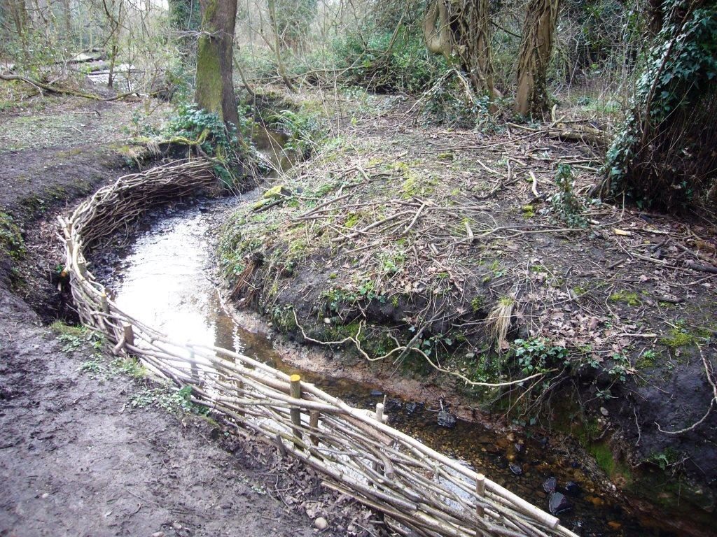
The spread of stones and charcoal extends for several metres along the stream bank.
Now continue along the boardwalk a little further until the stream straightens out and the ground is flatter (before a fork in the path.

This is where the actual sweat lodge would have been located. Excavations on comparable sites close by have revealed evidence of structures made of thin branches driven into the ground and most likely bent over to form a tent like structure which could be covered in animal skins.
Inside several people could gather around a hollow containing hot stones taken from the nearby fire and water taken from a stream could be poured onto the stones to create steam. On some sites a rectangular wood lined tank set into the ground has been found which would have held water for this purpose.

This interpretation is supported by ethnographic evidence from north America and northern Europe where such ‘sweat lodges’ were recorded in the past and in some cases modern versions are still used today. Several experimental reconstructions of sweat lodges have been undertaken at Moseley Bog to test these theories.

Take the left fork in the path ahead and you come to a platform overlooking an area of wetland full of rushes.
This is probably what much of the area of Moseley Bog looked like in the Bronze Age. Even in early times it was probably regarded as a magical place and the sweat lodges could have had religious significance or be associated with important social occasions through the year.

Continue on the boardwalk turning first to the left and then to the right at the junction and continue until you reach a bridge (to your right) over the stream and a flight of sleeper steps going up a broad high bank of ground ahead of you and to the left. This bank is the dam of a 17th or 18th pond which powered a corn mill at Sarehole Mill and the millpond filled most of what is now Moseley Bog.

Brickwork in the gap where the stream cuts through the dam is the remains of a sluice system to control the water level in the pond. (Exit the site here taking the steps over the dam, into Pensby Close, if you wish to visit Sarehole Mill).

Take the steps to the left up onto the top of the dam and follow a narrow sleeper path along the top until you come to a pond. This pond is in the base of a large hollow formed when material was extracted to build the dam.
It later became a garden pond. Note how the end of the dam curves around away to the left giving it extra strength.

Turn to the left at the end of the dam and walk up a rough narrow path bearing to the right (stay on the main path) until you reach the brick foundations of a group of former glasshouses and outbuildings once located in the gardens of Victorian houses built on high ground to your right where a modern school is now located.

Continue on the path constructed of tree branches and brick paving (this can be muddy!) then along another narrow sleeper path which zig-zags through boggy ground.

J R R Tolkien lived near Moseley Bog as a boy and the place inspired his descriptions of ancient forests in his books The Lord of the Rings and The Hobbit.

Upon reaching another boardwalk turn right and continue up the slope until you come to another information panel and a red shale path going to the left along the edge of an open field. This will bring you back to the car park.
The burnt mound is a scheduled monument which means it is protected by law. This means metal detecting and unauthorised digging at the site is not allowed.
You can also visit Sarehole Mill, an 18th century watermill with links to J R R Tolkien about 600m walk from the pedestrian access to Moseley Bog off Pensby Close (turn right at the millpond dam to leave the site). There is an admission charge for the mill but the café, gardens and visitor centre are free.
For opening hours see: http://www.birminghammuseums.org.uk/sarehole
Refs:
- Hodder, M, Birmingham the Hidden History. (2004 /2011)
- L H Barfield and M A Hodder, Burnt mounds in south Birmingham: excavations at Cob Lane in 1980 and 1981, and other investigations, Transactions of the Birmingham and Warwickshire Archaeological Society 114 for 2010, 13-46
Links:
https://historicengland.org.uk/listing/the-list/list-entry/1020542
http://www.bbcwildlife.org.uk/nature-reserves/moseley-bog-joys-wood-nature- reserve/explore/map-bog