
Ryknield Street
What is it?
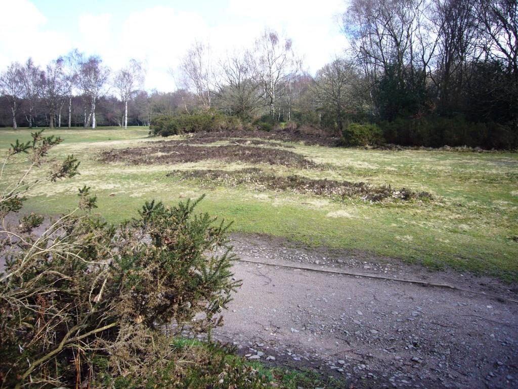
A well preserved section of a Roman road visible as an earthwork in Sutton Park, Sutton Coldfield.
Maps
Ordnance Survey- Landranger Map 139
Explorer Map 220
Grid reference Between SP084965 and SP088985
Parking - There are car parks at Streetly Gate and Banners Gate. Fees may apply. http://www.birmingham.gov.uk/suttonpark
Public transport – Buses from Sutton Coldfield and Walsall stop near Banners Gate on Chester Road North; near the Parson and Clerk Carvery for Royal Oak Gate and on Thornhill Road near Streetly Gate. The nearest rail station is in Sutton Coldfield to the east of the park, approximately a 4.5km walk through the park to the Roman road or take a bus from Sutton town centre.
For bus and rail information see
http://www.networkwestmidlands.com/

Access - The site is in public open space with footpaths and cycle routes. Access to walk along stretches of the road is possible but in places over rough ground and with some vegetation cover. Note also that you may encounter animals grazing in various locations in the park. Care should be taken when walking along the road where it passes through the golf course. There is a refreshment kiosk (limited range) and toilets at Banners Gate (playground). There are places to eat in Streetly Village north of Streetly Gate and The Parson and Clerk Carvery close to Royal Oak gate – both just outside the park. Other facilities inside the park are some distance from the Roman road.
For a downloadable map see http://www.sutton-coldfield.net/parkmap.html
There are markers in places along the route and interpretation panels at the main car parks.

What you can see
A 2km section of a Roman military road joining forts at Wall (near Lichfield) and Metchley in Edgbaston, usually known as Ryknield or Icknield Street, built as part of the Roman conquest of the West Midlands. The line of the road survives well here because it was incorporated into a medieval deer park. It is one of the best places in the country to see a Roman road.
From Banners Gate car park, follow the main path through a gate in the corner of the car park alongside a wooded area (Westwood Coppice) to your left and open parkland to your right.

At the end of the woodland continue straight on until you reach a junction with a red shale path (Lord Donegal’s Ride) and turn left. You will shortly see raised ground under grass on the right hand side. This is the Roman road and has a straight path running along the top of it.
On the other side of the shale path the same bank can be seen disappearing into the woodland and can be explored although it can be quite overgrown. (NOTE – if entering the park from near the Parson and Clerk Carvery take the path leading from the Royal Oak Gate near the junction of Chester Road North and Sutton Oak Road.
Ignore the first path going into woodland and carry on until reaching open ground and look for the Roman Road path going off the your left.)

This ridge of high ground or agger is up to 8m wide in places and supported the main Roman road surface. The raised bank helped to provide good drainage for the road, especially useful in the British climate!
Excavations have shown that it consists of compacted gravel, never having any sort of paved surface.

As you walk along the path look to both sides and every so often you will see long, relatively narrow ditches a few paces from the agger.
These were dug by Roman surveyors to mark out the route of the road whilst it was under construction. It indicated where vegetation would have to be cleared away by those building the road.

Further away beyond these ditches, there are pits and hollows where gravel was dug out to make the road. You will see these at various places along the route.

When you reach the golf course cross the green with care and take a gravel path into woodland beyond. Here the footpath runs alongside the agger and in the trees to the left you will see more of the ditches and gravel pits associated with construction of the road.

Eventually you come out onto another area of golf course – be aware of players, they will indicate if they are taking a shot! – and cross into the next section of the footpath running through an area of woodland planted in 1977 to commemorate the Silver Jubilee.

Beyond this walk to the right across a steam and you will see the slight raised line of the agger running beneath the green of the golf course. Cross the green with care aiming for a path just to the right of a white painted post. To your right is a well preserved section of the agger with trees planted on it.

The path is less obvious here but continue and look out for a tall post with a cross on top marking the route of the road where it crosses another green. This post may have been put there when the area was being used by the military to indicate that there was an ancient monument here.
Where you reach another gravel path, you will see the raised agger, with heather growing on it, crossing the green and into the woodland beyond. Walk to the left of the woodland and take a path that skirts around the left side of a tee and bunkers keeping an eye open for golfers.

Carry on across the grass and eventually you will reach an access track for the golf club. Note the concentration of large gravel in the surface where the track crosses the agger.
You can also see on the other side of the track the 16th- century bank and ditch boundary of Streetly Wood which was constructed across the Roman road.

It is difficult to follow the agger through Streetly Wood where it is quite overgrown and there is no clear path.
From here you may choose to return back to where you started or explore the agger in the woodland.
To see another section of the Roman road turn left along the access road then take the path forking to the right, past the first tee. This takes you around the western edge of the woods until you arrive at Streetly Gate car park where you will find an interpretation panel.


At Streetly Gate follow the path going off to the left of the main drive, behind the car park. Take the second path forking off to the right of this path and you will soon see the now familiar raised agger where the path crosses the road.

This is a good place to see some of the gravel pits used to extract materials to build the road. You can explore the agger here where it goes through the woodland then return to the main path.

Continue on this path to a railway line and cross over the level crossing with great care.

The path here will lead you along the final section of the Roman road running through woodland on your left before enters open ground and eventually leaves the park.
The site is a scheduled monument which means it is protected by law.
This means metal detecting and unauthorised digging at the site is not allowed.
There are many other features of archaeological interest in the park the most important of which are included in way marked trails available at http://www.fospa.org.uk/ais/aisindex.html
Note these trails are being updated and some markers may be missing.
Find out more:
Hodder, M, The Archaeology of Sutton Park. (2013)
Links: http://historicengland.org.uk/listing/the-list/list-entry/1020420
http://www.birmingham.gov.uk/suttonpark